Beacon Fell Virtual Courses (Yellow, Middle, Score) 2024
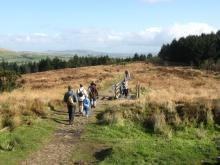
Beacon Fell Country Park comprises 110 hectares (271 acres) of woodland, moorland and farmland. The Beacon Fell summit is 266 metres (873 feet) above sea level and offers spectacular views of the Forest of Bowland and Morecambe Bay. On a clear day, seeing the Isle of Man is possible. Wildlife is abundant for those who are prepared to be observant. Rabbits and hares are frequent and are easily spotted. Roe deer are a little more elusive, but patience may well be rewarded! Stoats and weasels can be seen running across the road or clambering over the dry stone walls. As many as 11 species of dragonflies and damselflies may be seen around the ponds during the summer months.
The woodland trail
The woodland trail takes about 40 minutes to complete, taking you past Larch Avenue, Shield Wood, Tarn Wood, Middle Wood and the summit. As you go round the trail you will see the different species of trees that have been planted in the wood and the different habitats that they have created.
Sculpture trail
Starting at the Orme Sight adjacent to the visitor centre the trail leads up to the summit of Beacon fell. The trail features a number of sculptures carved by local artist Thompson Dagnall.
Fellside trail
The fellside trail is a circular route provided for horse riders. The route takes approximately one hour to complete.
Beacon Fell summit
A triangulation pillar is situated on the site of where the beacon would have stood. Records show that there was a beacon here as long ago as 1002 AD. Later maps show it as part of a chain used to warn of impending danger such as the approach of the Spanish Armada in 1588. More recent beacons have been used to celebrate such occasions as coronations and jubilees. Rising to a height of 266 metres above sea level the summit gives fantastic panoramic views of the Bowland Fell and Parlick Fell.
| Beacon Fell Middle | FREE | |
| Beacon Fell Score | FREE | |
| Beacon Fell Yellow | FREE |
| Beacon Fell Middle | FREE | |
| Beacon Fell Score | FREE | |
| Beacon Fell Yellow | FREE |
Download from this portal for free (maps updated 01/10/24).
Virtual Orienteering Safety Aspects
You are reminded that your take part in this activity at your own risk. Let someone know what you are doing.
As with any countryside activity, there are various hazards that you need to be aware of and you need to take action to avoid these to remain safe. These include :
Slippery paths/slopes, especially where steps (wet leaves and perhaps ice), and uneven surfaces including tree roots.
Large crags/cliffs and other rock features. (particularly Williamson Park)
Lakes and ponds – slippery margins.
Prickly vegetation.
Branches/twigs
Moving vehicles in public car parks and access roads
Members of public, dog walkers, cyclists – please avoid and be courteous to.
If you are running alone please make sure you inform someone of your plans
SROC have completed a Risk Assessment for this activity
Maprun Smart phone App
This is a Virtual Orienteering course, where your phone uses GPS to register at the start, the controls and the finish. Your phone beeps each time. Then upload your results to see your position on the leader board.
Download the Maprun V7 app for free
Probably best to download the app and the course to your phone when you have wifi, but it can be done at the venue if you have data. Enter your name to appear in the results.
To use the Maprun app scan the QR code on the map and click OK, wait a few seconds.
Click ‘go to Start’ when you are ready. When you get near the start your time begins once your phone beeps.
Make sure your GPS is on and that you are not in power-saving mode.
One final tip - if your phone does not beep at a control but you know you are there, just carry on - you can review your result using the Review Results function (top right menu bars) when you finish.
For more about maprun see http://maprunners.weebly.com/
There is now a MaprunG for use with Garmin and certain other watches.
The Beacon Fell courses are in the folder ... UK/Lancashire/Preston - SROC
If you have any queries or want more information please email Development@sroc.org